WALKING AN ANCIENT BORDER
Words By: Marcus Samperi Photography By: Mike Jones and Marcus Samperi
History teaches us that borders are the source of many disputes and none quite so fraught as those separating countries. As a species humans are very territorial and are ready to fight and die to protect their land from invading forces. Even in the present day borders are still the source of many issues that can result in conflict, bloodshed and loss of life. Saying this, borders can provide some of the most exhilarating, picturesque and challenging hiking routes especially those located along natural ridgelines, mountain ranges or riverbanks. One such route is the Offa’s Dyke Path running along the English-Welsh border.
This path follows the route of a manmade dyke – 'a low wall or earthwork serving as a boundary or defence’ (Oxford Dictionaries) complete with a ditch on the Welsh side – built on the orders of King Offa of Mercia during the 8th century. This dyke stretched approximately 140-miles (225km) beginning in the north where the River Dee meets the sea and ending at the River Wye in the South, the remaining miles consisting of natural mountain ranges. Offa was the King of what was a ‘warrior tribe’ who seized power during deep unrest. During his reign he expanded the Mercian territory to cover the vast majority of southern England including the Kingdoms of Kent and Sussex whilst becoming a close ally to the Kingdom of Wessex through the joining of the family's in marriage. Offa’s legacy was bloody; legend has it that he even murdered the King of East Anglia days before he was due to marry his own daughter Elfrida at the request of his wife Queen Cynethryth who was jealous of her daughter’s happiness. Offa had regular battles with the Welsh throughout his reign and thought that by building the dyke it would keep them out of the Kingdom of Mercia; however, he wouldn’t live to see it completed. It was during one of these battles in 796AD that Offa was killed in action.
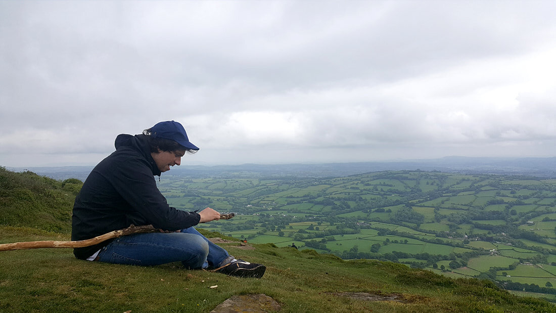
Today the Offa’s Dyke Path is an official national trail and is regarded as a challenging trek stretching 176.8 miles (284.6km) in length. The route is far from flat with ascents totalling 9085 metres (29,806ft) but never rising above approximately 700 metres (2297ft) in height at any singular point. It is rumoured to be the training ground for the S.A.S. (Special Air Service) who aim to complete the distance within 5 days. However, it is more common to take 12-days or longer to complete in its entirety, giving time to really enjoy the landscape surrounding it and the towns and villages that line the route. Even though parts of the dyke are still in existence today it isn’t along these sections that hold the most challenging terrain. Rather it is the more mountainous regions that pose the biggest challenges. Early on in the trek it became obvious to us why many borders coincide with natural land changes. We had just ascended a steep gradient leading to the top of the Black Mountain Range on the edge of the Brecon Beacons National Park. To the west was the undulating mountainous region of Wales; and, to the east was England with miles-upon-miles of flat farmland as far as the eye could see. It just seemed logical to have the border between these two countries where the mountains finish and the land levels out. Also from a security perspective: what could act as a better barrier than a natural mountain range? It is no wonder that historically – and still in many areas of Wales today - a different language is spoken on either side of this divide.
The going was tough as we followed the path north not only with the continual ascending and descending over the undulating terrain but with the sheer distance we were covering, averaging around 18.5 miles (30km) per day. This was double what we managed in training. We had also opted to be as self-sufficient as possible by carrying camping gear, clothing, food, cooking implements and water - sometimes up to 4-5 litres each per day. Our backpacks felt heavy and cumbersome weighing approximately 15kg [maybe more]. Our fitness wasn’t the greatest; training sessions always ended in either a pub or café gorging on less than ideal treats and we were both carrying a bit too much body weight. As a result the first few days were a shock to the system not helped by the somewhat treacherous conditions caused by periods of torrential rain. Our lack of experience in multi-day, multi-terrain treks and our limited training became acutely obvious: we were having to put in the hours, sometimes between 10-14 hours per day, just to keep on schedule. Our daily progress was slow. However, due to this, we were lucky to witness numerous sunsets whilst out on the trail. On a clear evening as the sun began dipping below the horizon it would bathe the Welsh countryside in a deep yellow glow. With it brought an extra boost of energy that would help propel us to the next campsite and the sanctuary of our tents.
The trail was not short of interesting terrain but traversing the scree slopes of the Eglwyseg [Egl-why-zig] Mountain was both exhilarating and scary at the same time. The guidebook (‘Offa’s Dyke Path’ by Ernie/Kathy Kay and Mark Richards) called for: “a good sense of balance [during] an exhilarating walk, with wide views to the west, the crags above, rock violets in the scree at your feet, and probably kestrels and jackdaws, which nest in the crevices, overhead”. Reading this from the comfort of our tents, having overcome all the other hurdles that had crossed our path, didn’t give us any cause for concern.
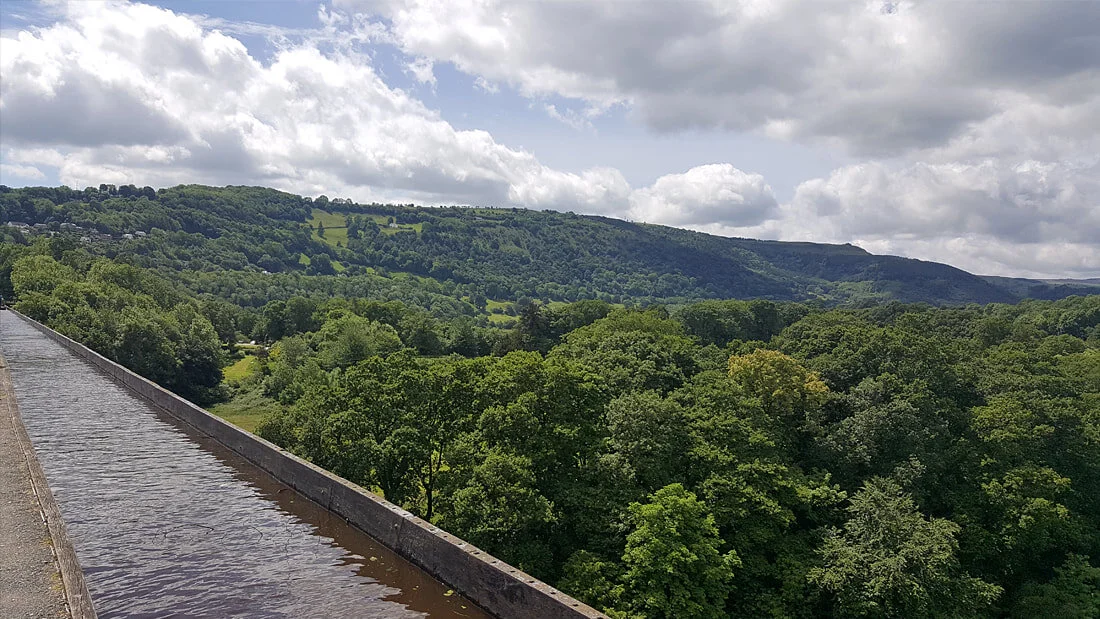
The following day began as many of the previous ones did – ascending a hillside. To our surprise, after a few miles, the trail merged with a road that was heaving with people. We had become so accustomed to being on our own that it felt uncomfortable having so many people around. The smooth road was a welcome relief and allowed us to cover a substantial amount of miles in a shorter period of time. It continued this way through the town of Froncysyllte towards Trevor and the famous Pontcysylite Aquaduct never really deviating away from the road for long. Although it had been a pleasant change we were happy when the trail reached Trevor Hall Wood and peace and tranquillity was restored.
Not before long the wood turned into a disused quarry. We were met almost immediately by a grey landscape covered in rocks, boulders and stones; it was like the area had been drained of all colours. It was a stark difference from the delicate green and brown tones of the wood. It felt aggressive, unfriendly and dangerous as we proceeded over the now rocky terrain towards a gully complete with a gushing stream. The landscape opened up; what lay ahead were steep scree slopes following the contour of the crags above. We were high above the treetops without a clear route across. For the first time on this trail we were struggling to find our way.
The trail had seemingly just stopped. We began searching the area looking for something that resembled a useable path. Nothing. Not even an official Offa’s Dyke national trail sign. We carried on searching. Scrambling to the top of a large boulder to gain a better viewpoint revealed a worrying sight. We could just make out what looked like a terrifyingly thin walkway that seemed to cross the mountainside. It couldn’t have been any wider than half a metre (1.5ft) with a steep scree slope inches from where we would be walking. The gradient so steep that it was a distinct possibility that a fall could have serious repercussions. The guidebook was correct when it stated that ‘a good sense of balance’ was needed. As we made our way towards this narrow walkway we found an official national trail sign lying on the ground confirming that this was indeed the way through the scree.
The atmosphere had gone eerily quiet, my heart beating hard and fast with sweat dripping down my forehead. I wasn’t a fan of ridges at the best of times and this was just petrifying. We were attempting the Offa’s Dyke Path early in spring; I was certain that as the walking season got into full swing that this narrow walkway would become well trodden making it slightly wider and seem less fragile. For now, my main concern was: what if we meet someone coming the other way?
As we began our traverse we became acutely aware of not only our big heavy backpacks but also the wind. We were very exposed on this part of the trail and it felt precarious. The going was perilously slow to begin with but with every step our confidence grew, we felt more comfortable and started to enjoy the adrenaline rush. At one stage even stopping to fully admire the huge crags towering high above and the views over the valley below. We really felt insignificant and small compared to the environment around us. Standing there and letting the cool breeze blow onto our exposed faces we could hardly believe where we found ourselves; this really felt like true wilderness. We were in an absolutely stunning location: vast, huge, intimidating yet dangerously beautiful. As we continued our precarious traverse around Craig Arthur we could see in the distance just past Craig yr Adar that the narrow walkway slowly began widening re-introducing grass to the landscape. The green colour was so vivid amongst the greyness of the scree that it looked welcoming. It was the perfect place to stand and look back over the crags to fully appreciate where we were: the harsh beauty, sheer size and dominance over the landscape. The range of emotions that it provided epitomised the very essence of what the Offa’s Dyke Path had become: all consuming, challenging, adventurous, harsh and long. At its very core it contained all the natural ingredients of an awe-inspiring adventure.
Offa may have ordered the creation of this dyke to keep the Welsh out of the Kingdom of Mercia, to defend his borders and to aid his battles. His choice to build it along the border making use of the natural mountain ranges may have made sense in terms of defence. But now in peacetime unified Britain what Offa created was an almighty path that unites anybody who attempts it whether in part or as a whole. It was created for the sword but has ended up being for the soul.